[:pl]
Wpis stanowi kontynuację artykułu, który opisywał potencjał lotnisk obliczony na podstawie odległości w określonych buforach, czyli równej odległości od punktu. Nie brano wtedy pod uwagę sieci drogowej.
W tym wpisie głównym kryterium obliczenia dostępności lotnisk jest sieć drogowa Polski. Dane pochodzą z projektu OpenStreetMap (stan na wrzesień 2014) oraz z Centralnego Ośrodka Dokumentacji Geodezyjnej i Kartograficznej.
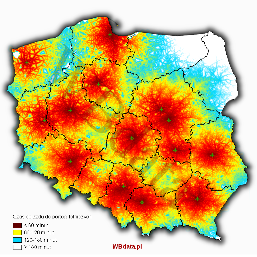
Na podstawie prędkości różnego typu dróg, obliczono czas jaki potrzebny jest by dotrzeć do każdego z 14 portów lotniczych w Polsce.

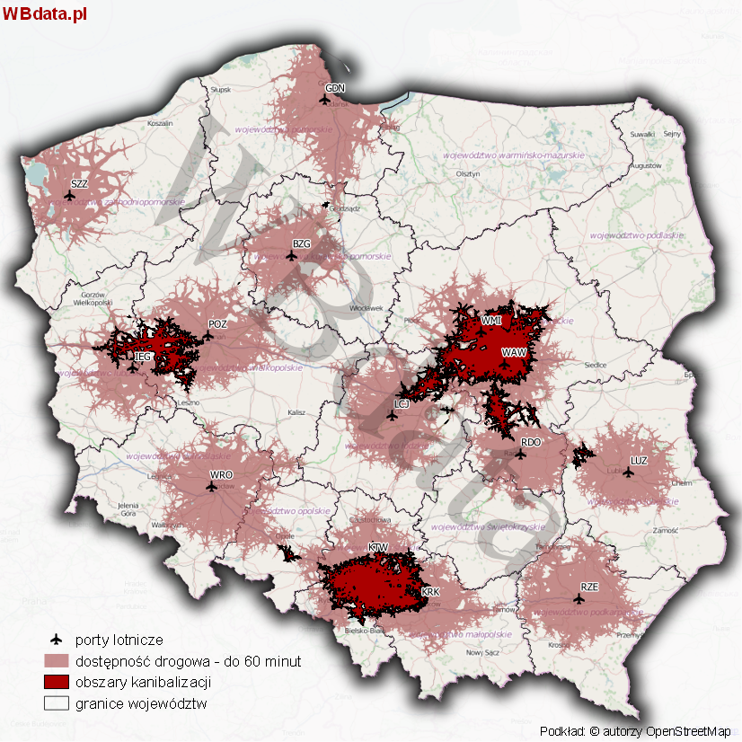
Mając takie dane można wyznaczyć obszary zasięgu oddziaływania dwóch lub więcej lotnisk (obszary kanibalizacji). Na poniższej mapie przedstawiono obszary kanibalizacji wyznaczone po nałożeniu się zasięgu obszarów o dostępności 1 godziny do każdego portu lotniczego.

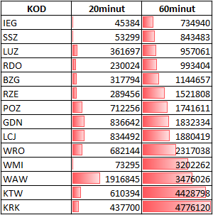
Po wyznaczeniu obszarów zasięgu oddziaływania lotnisk można obliczyć ilu potencjalnych pasażerów mieszka w strefie dostępności transportem drogowym. Dla przykładu w poniższej tabeli przedstawiono liczbę ludności w strefie 20 i 60 minut od lotniska.

Z tabeli można również wywnioskować odległość danego portu od dużych miast – najbardziej jest to widoczne w Warszawie, gdzie Okęcie leży w Warszawie (WAW), a Warszawa-Modlin (WMI) poza stolicą.
Analiza została sporządzona bez uwzględnienia kongestii transportowej.
To tylko przykład analiz, które można bardzo szczegółowo opisywać i obliczać w wielu wariantach, a także obliczać liczbę ludności w różnych zakresach czasowych. Wizualizować można w małej lub wielkiej skali, w zależności od potrzeb.
Tutaj znajdziesz najaktualniejsze analizy dotyczące dostępności lotnisk.
[:en]This post is a continuation of the article, which described the potential of the airports, calculated based on the distances in certain buffers, i.e. equal distance from the point. The road network was not taken into account then.
In this post, the main criterion for calculating the accessibility to airports is Poland’s road network. The data comes from the OpenStreetMap project (status as of September 2014) and the Centre for Geodetic and Cartographic Documentation.
Based on the speed of different types of roads, the time needed to reach each of 14 airports in Poland has been calculated.

With this data, it is possible to designate the areas within the impact range of two or more airports (cannibalisation areas). The following map shows the areas of cannibalisation, defined following overlapping the ranges of areas with accessibility of 1 hour to each airport.

Having specified the catchment areas of airports, the number of potential passengers who live in the area of accessibility by road can be calculated. For example, the following table shows the population in the zone of 20 and 60 minutes’ distance from the airport.

The table can also be used for inferring the distance between a given airport and big cities – this is most apparent in Warsaw, where Warsaw Chopin Airport is located in Warsaw (WAW), while Warsaw Modlin Airport (WMI) is located outside the Polish capital.
The analysis has been prepared without taking into account the transport congestion.
This is just an example of analyses that can be described in detail and calculated in many variants. Also, the number of people in different time ranges can be calculated. Visualisation may be carried out on a small or large scale, as needed.
[:]